TMA-1: The Martian Artifact
Part 1
A Sign of Intelligent Life on Mars
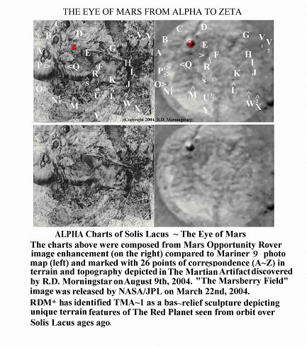
A Martian Sculpture Depicts “The Eye of Mars”
by Robert D. Morningstar
(Copyright 2004-2006-2021, RDM*)
“For All the World to See…”
“TMA-1: The Martian Artifact” was originally presented at The 2nd Annual Regional Mini-Technical Conference of American Institute of Aeronautics and Astronautics (AIAA) held at Johns Hopkins University, Applied Physics Laboratory, Laurel, MD on October 30th, 2004. “TMA-1” was revised in October 2005 and September 26th – October 1st, 2006 in order to incorporate supporting material released recently by NASA/JPL under new public information policies initiated by Dr. Michael Griffin, former President of AIAA, and new Director of NASA.Prologue
“The first requirement of a scientist is that he be curious.
He should be capable of being astonished and eager to find out.”
— Dr. Erwin Schrodinger
(Pioneer in Quantum Mechanics and philosopher of science)
I am writing today to relate to you details of a remarkable discovery made on the planet Mars by the Mars Opportunity Rover in March 2004.
On August 9th, 2004, after nearly 5 months of study, I discovered (perhaps “recognized” is a better word) an object that was found and photographed on Mars by the Mars Opportunity Rover on March 25th, 2004.
Following 5 months of intensive study and scrutiny, the object was found by this writer to be an artificially created artifact, carved in relief in Martian stone in The Eagle Crater in a region of Mars called Meridiani Planum.
From the first moment that I saw it on the NASA/JPL website on March 26th, 2004, my instant and immediate “gut reaction” was “My God! That looks like art!” And so, it turned out to be: Martian art, hence, the name I gave it, “TMA-1: The Martian Artifact.” Now, after 20 years, one of many artifcacts of Martian origin found on The Red Planet Mars by several independent recsearchers.
NAGASAKI DAY 2004
After 4 and half months of research into the nature and origin of the object, it was on August 9th, 2004, while analyzing the NASA/JPL photo released on March 25th, 2004, that I suddenly discovered (“uncovered” might be more accurate) that the unusual object of my study was actually a sculpture, executed in a hemispherical relief, on a slab of Martian stone in the region known as Sinus Meridiani. I dubbed it TMA-1 or “The Martian Artifact.”
Sinus Meridiani (situated on the Prime Meridian of Mars, hence, its name) had been chosen for the Opportunity Rover mission by NASA specifically for close-up study based on scientists’ conclusion that the region was a very likely a site where, in primordial times, water had existed in great abundance. The proof of concept was found in the discovery of vast fields of hematite beads. Hematite precipitates and forms in water.
For a week or so, in early August 2004, I had been attempting to correlate and match the detailed contours depicted in TMA-1 to the Hellas Basin, which I had seen first hand the previous August. Then my colleague, Charles Fielding, and I embossed a radar altimetry map of Hellas Basin and saw that the floor of Hellas Basin did not match the floor topography of The Martian Artifact”, eliminating Hellas Basin as the terrain form depicted on “TMA-1: The Martian Artifact.”
In a flash, I saw my error: I had been looking at the wrong region of Mars. I quickly realized that it must surely be another region, Solis Lacus, for the area depicted on TMA-1 was far too vast to be Hellas Basin as depicted on the bas-relief sculpture in proportion to the planet.August 2003: Viewing Mars’ Closest Approach in 60,000 Years
One year before, from August 26-29th, 2003, I had viewed The Red Planet for 3 straight nights, using a 128X Super Ploessel lens and a Meade 8-inch auto-tracking telescope. This came about during Planet Mars’ closest approach to Earth in 60,000 years!
When I compared the NASA/JPL image of TMA-1 (dubbed by them “The Berry Bowl”) to Mars Global Observatory images and Mariner 9 photographs, I was stunned at first to recognize the major chasms of Vallis Marinaris, which I had observed first hand during my observations, depicted in both photos and the artifact. This characteristic was far beyond the laws of chance and the features shown were so explicit that it could never be ascribed to “wishful thinking” in anyone’s wildest imagination. “TMA-1: The Martian Artifact ” is precisely that, “a fact”, not an illusion of light and shade nor an illusion nor a hallucination of an over imaginative mind.
I sat at my computer quite stunned. “Electrified” is a more accurate description of my reaction, as there before me, I recognized the unique contours of Ophir, Candor and Mellas Chasmata, which are accurately depicted in detail in TMA-1.
“The Martian Artifact” is, indeed, quite simply, “a artifact of Life.”
The object, called “The Berry Bowl” by NASA/JPL and nicknamed “TMA-1” by this researcher, appears to me to be a bas-relief sculpture, depicting the most significant geographical and geological features of the planet Mars, itself, called by astronomers, “The Eye of Mars.” Astronomers had observed “The Eye of Mars” regularly for many years but it remained an unexplained phenomenon until now. The first one to see it was Percival Lowell working at Kit Peak Observatory.
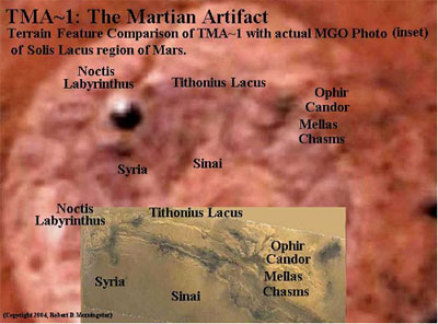
TMA-1. “The Martian Artifact,” captures the topography of Mars in 3-dimensional relief, including an extremely accurate depiction of the Valles Marinaris, with its long, winding twin trench canyons called Ius and Tithoneus. It delineates the contours of Ophir, Candor and Mellas Chasmas, as well as, the adjacent region, Solis Lacus, which in darkness forms the pupil of “The Eye of Mars.” TMA-1 renders the topography of unique ridges, mounds, valleys and the steeply incline slopes and palisades of surrounding of regions named “Syria” and “Sinai” by NASA.
From the first sight of “The Berry Bowl” back on March 25th, to my own eyes, the object’s design, rounded form, and convoluting contours within a perfect circular pattern, instantly (and intuitively) conveyed to me a single and, literally, “earth-shaking” idea:“My God! That looks like Art!”
Furthermore, in studying “The Berry Bowl” over a 5-month long period, its exquisite forms and contours emerged and revealed it to be an intelligently designed and sculptured 3-dimensional artifact.
Comparing it with Mariner 9 photomaps, I discerned the same steep slopes of Syria depicted in the computer images, showing the same meteor impact craters registered in the Mariner photomap. I could also make out the precipitous and winding palisades of the region along southern Valles Marinaris, known as “Sinai.” TMA-1 even depicts the smaller impact craters, which are found in several areas in the slopes of Syria and the cliffs of Sinai.
*******
TMA-1: The Martian Artifact –
Part 2
A Sign of Intelligent Life on Mars
A Martian Sculpture Depicts “The Eye of Mars”
TMA-1 clearly appears to be an intelligently conceived and designed form.. If so, this alone, of course, would indicate (and prove) the presence or ,more likely, the previous existence of intelligent life on the Red Planet. The photograph, released by NASA/JPL on March 25th, is shown below, enlarged and enhanced by this writer.

A Sign of Intelligent Life on Mars Uncovered
The object, which I describe as a bas-relief sculpture is carved into of a slab of Martian rock is called “The Berry Bowl” by NASA/JPL. This is another instance of NASA naming serious subjects with vcomical, dismissive names as part of their technique to distract people from seeing what is really there. I cite tis as another example of what I call “Disinformation Technology,” which sometimes involves manipulation of graphic evidence to hide what is iin the photos of videos, or at other times emply neurolinguistic techniques to disemble and distract readers’ attention, using dismissive terms, jargon or phrases (like calling UFOs observed oover the Moon by Apollo astronauts as “Moon Pigeons” or “Santa Claus”)..
The object, which is carved in relief and I dubbed it “The Martian Artifact” or “TMA-1.” tMA-1 is shown above just left of center in the photo, depicts the planet Mars, itself, with extreme” accuracy, and particularly, the topography of Solis Lacus, a significant region of southern equatorial Mars, known as “The Eye of Mars” (for reasons that I shall describe later).
I now believe that this artifact, TMA-1, may be a “Time Capsule”, or the remnant of a larger one, containing a message, intended to call attention to the region or, perhaps, to record the circumstances or forces, which caused a cataclysm that destroyed Mars’ once Earth-like ecosystem.
WHY HASN’T NASA RECOGNIZED IT?
Why has NASA not come forth with more information on this important event? Other than presenting it in its only press release to date in what they described as a “whimsical” (and, in my opinion, almost comical) manner, dubbing it facetiously “The Berry Bowl.”. Since then, there has not been a single reference to it, despite the claim in the original press release that it was left uncovered for future study. Is NASA psychologically blind-sided in this or is there another explanation?
It may well be that NASA has failed to recognize the object for what it really is.
Could it be “tunnel vision”, “blind-sidedness” or was there another cause for hesitation or oversight? Perhaps, NASA scientists are not allowed by their official policy or scientific paradigms to recognize such an artifact. A reluctance to recognize it may be that NASA scientists are constrained from publicly acknowledging, asserting belief in or revealing the existence of extraterrestrial life. No one wants to be the first to risk ridicule and lose credibility or career.
It is also possible that someone within NASA/JPL, a concerned scientist, leaked the photograph so that someone, like myself, might recognize it and come forth to characterize it.
And so, on October 30th, 2004, on the 66th anniversary of Orson Wells famous “War of the Worlds” broadcast, I journeyed to Johns Hopkins’ University to communicate to AIAA members my discovery, impressions and geometric proofs that “TMA-1” or “The Berry Bowl” was intelligently designed to call our attention to a particular region of Mars.
NASA’S OFFICIAL POLICY PREDICAMENT
To really understand the official NASA non-disclosure policy (prior to Dr. Griffin’s appointment), we must first remember an important historical point. NASA internal policy prohibits disclosure by command and control mechanisms engineered and implemented after the Brookings Institution 1960’s report on “Peaceful Uses of Outer Space”.
In that report, the Brookings Institution recommended prohibition of disclosure, with a warning against the revelation of the existence of extraterrestrial life to the people of America or the world. Brookings Institution thinkers feared social, economic and religious upheaval would result. The Brookings Institution’s conclusions were based on the now famous events, which transpired 66 years ago, the public reaction to Orson Wells’ radio broadcast of “The War of the Worlds” and the local panic that ensued.
AUGUST 26-28th, 2003:
MARS’ CLOSEST APPROACH to EARTH
IN 60,000 YEARS
Many of us, “Marsologists,” were fortunate enough to observe Mars nightly during the planet’s closest approach to Earth in 60,000 years in 2003. From the 14th of August, the night of the New York City blackout, through August 30th, I viewed Mars nightly.
From August 26th through the 29th, I made detailed telescopic observations for 2 to 3 hours each night. With these detailed observations of Mars in August 2003, and comparing them daily with NASA Hubble Space Telescope (HST) photo imaging of Mars, this researcher studied the southern hemisphere and equatorial region of Mars in great detail. Since it was facing us directly, a vast area called “Solis Lacus,” known by astronomers as “The Eye of Mars”, emerged as Mars’ most significant, awe-inspiring and memorable terrain feature on the night of the 27th-28th, 2003.
From August 26th to August 29th, ’03, I viewed The red Planet, from it’s nort pole to the regions of the South Polar Cap, with its spike like mountain peak, radiating and refracting light appearing to my eye like aglistening “unicorn’s horn.” With the sun’s light underoing as Rayleigh Scattering, i could see the ligh interacting with the Aurora Australis of Mars, making Mars appear brilliant to the human eye, much like a pink neon globe.

August 9th, 2018
Mars’ airglow made its atmosphere visible for miles above its surface, and imposing a pink-red-orange, electrified halo on the entire planet. I observed 2 long streams of south-to-north alto-stratospheric cloud formations, stretching north from Tharsis Montes.
These almost identical cloud formations paradoxically appeared to be parallel, tubular altostratus clouds, which spun in the same direction, like two white marble columns rolling in the same direction and extended from Tharsis Montes to the far north for over a thousand miles, parallel to the Tharsis Bulge and over the Albus Tractus Borealis.
Only now, 2 years later, with detailed knowledge of the topography of region of Tharsis and Xanthe, do I understand the orographic (terrain formed) nature of the twin tubular, parallel jet streams.
HELLAS BASIN: “THE SEA OF CO2”
On the night of August 26-27, ’03, I studied in detail, a region of southern hemisphere known as the Hellas Basin and witnessed, much to my surprise, huge, billowing banks of fog, rising from Hellas Basin as sunlight, traversing it, revealed many layers of terraced slopes, reminiscent of the striations of the Grand Canyon, and reflecting every hue of red, rose, sienna, umber, brown, purple and black. The ever-darkening nether regions of darkness in the basin can very accurately be described as “hellacious”.
Hellas Basin possesses unique atmospheric and terrain characteristics. This vast impact crater, approximately 600 miles wide, contains what could be described as a “Sea of CO2”, looking like a small carbon dioxide ocean, which causes these effects above the surface.
The sea of carbon dioxide is contained by strong Martian planetary winds that seal the basin due to their pressure and velocity. The effect of the fog banks, rising from the crater, created the impression that I was viewing the immediate aftermath of a fresh asteroid impact, still smoldering after impact. The effect was shocking as I realized the magnitude of the original event and how it must have altered the entire planet’s ecosystem.
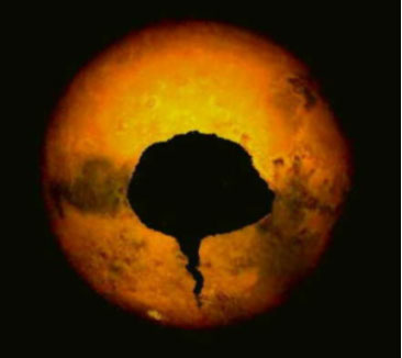
SEEING SOLIS LACUS: “THE EYE OF MARS”
Solis Lacus, a far greater impact region, is to be found not far away, also in the southern hemisphere of the Red Planet.. It is difficult to believe that Mars survived these two huge impacts and more. In contrast to the vaporous Hellas Basin, this region is usually depicted by NASA/JPL and HST photos as a vast, nondescript desert area near the Martian equator, immediately adjacent to the region called Valles Marinaris, a 4000 km. (2500-mile long) crack in the planet Mars. I observed Solis Lacus on the night of August 27-28th, 2003 for over an hour as the planet Mars turned and slowly brought it into view.
Solis Lacus is an area of vast depression covered by sands (if you believed the pre-2004 NASA photos). It was depicted in the computerized Hubble photos much like a Martian Sahara, nearly flat, overrun and filled in by Martian dust and sand.
However, in reality it appeared to me to be so deep that when sunlight strikes Mars, traversing its rim at low sun angles at morning and sunset, Solis Lacus remains in darkness, while the rest of the planet is bathed in bright sunlight for several hours. This explains the appearance and disappearance of “The Eye of Mars” during the course of the Martian day. (Reader take note: The sun angle is a very reliable indicator of the true angle of the slope of descending terrain into the central region of Solis Lacus.)
As the planet turned, a vast dark spot appeared, beneath a brilliant Martian airglow. This made Mars look to me like a gigantic eyeball and Solis Lacus looked like its pupil. Furthermore, another strange effect: the pupil bled a long black tapering tear to the south formed in the southern region called Thaumasia Fossa, a dry river bed or, more likely, another meandering fracture or fault line in the planet caused by the asteroid impact, which created Solis Lacus.
*******
TMA-1: The Martian Artifact
Part 3
A Sign of Intelligent Life on Mars
A Martian Sculpture Depicts “The Eye of Mars”
As the planet turned, a vast dark spot appeared, beneath a brilliant Martian airglow. This made Mars look to me like a gigantic eyeball and Solis Lacus looked like its pupil. Furthermore, another strange effect: the pupil bled a long black tapering tear to the south formed in the southern region called Thaumasia Fossa, a dry river bed or, more likely, another meandering fracture or fault line in the planet caused by the asteroid impact, which created Solis Lacus.
I felt like Ulysses looking into the eye of the wounded Cyclops, Polyphemus with terror and fear, Deimos and Phobos, in the pit of my stomach at the realization of the magnitude of the catastrophe that had formed “The Cyclopean Eye of Mars.”
The effect it had on my mind will always remain with me, unforgettable. The impression it made on this viewer is best expressed by simply stating:
“When I looked at Mars, viewed at its closest point to Earth in 60,000 years, Mars looked back.”
EYEBALL TO EYEBALL WITH MARS
This first-person familiarity, literally “eyeball-to-eyeball,” with Mars’ geography and topography proved invaluable one year later. The memory of the black pupil and bleeding tear, aided me in slowly recognizing “The Martian Artifact” over a 5-month period for what it now appears to be: a topographical sculpture of the Red Planet’s most significant feature. Except that “TMA-1” shows the same outline, contours but with the internal land forms and features as they would appear in full daylight under the light regimen of a Martian midday sun.
The realization was stark and shocking: The artifact is a bas-relief sculpture, accurately depicting every detail of “The Eye of Mars”, showing in minute detail its terrain contours and, perhaps, memorializing the disaster that altered the planet’s ecosystem and nearly destroyed the planet.
Since NASA was ignoring my new “pet rock” and, in fact, treating it facetiously with the name “The Berry Bowl” in my belief to disguise its significance. I took it much more seriously and the artifact was nicknamed “TMA-1” to honor Arthur C. Clarke, who predicted a discovery such as this in his novel, “2001: A Space Odyssey”.
Arthur C. Clarke, in “2001: A Space Odyssey,” described a fantastic lunar anomaly also known as “The Monolith” or the “Tycho Magnetic Anomaly 1,” which had been intended by its extraterrestrial designers to communicate its message geometrically (for those advanced enough to decipher it). The Tycho Magnetic Anomaly encoded and contained a message revealing intelligent design through its unique edges and their dimensions in proportions of 1: 4: 9, the squares of the first 3 numbers.
In Clarke’s story, TMA-1, Tycho Magnetic Anomaly 1, “The Monolith”, discovered in the lunar crater, Tycho, was a coded message, a radio marker beacon and a pointer directing mankind to explore the outer planets, specifically, Jupiter and its moon, Europa.
In September 2004, after 5 months of research and detailed geometric analysis of TMA-1, I wrote: “…comparisons of the Rover image with HST photos and Mariner 9 photos of the region’s terrain features have revealed TMA-1 to be a well proportioned and topographically accurate depiction of the whole region called Solis Lacus, ‘The Eye of Mars’, as it appeared aeons ago, at a time BEFORE IT WAS COVERED by Martian dust and sand.”
March 25-August 9th, 2004
That became the last sentence in the abstract that I submitted to AIAA for the 2nd Regional Mini-Technical Conference held on October 30th, 2004 in Laurel, MD. The abstract was selected for presentation. But as I was to discover, I was wrong, misdirected by images in NASA’s computerized Hubble Space Telescope photos, which prior to 2005-2006 and the appointment of Dr. Michael Griffin as the new director obfuscated the true nature of Solis Lacus and its features. It is not covered with sand and neither is it a “desert.”October 18th, 2004
On October 18th, 2004, I uncovered yet another important detail. I vividly recalled particular details of the Martian atmosphere, which I had noted previously on August 29th, 2003, showing me that Mars possesses a denser atmosphere than NASA had been claiming for many, many years. Mars also possesses a dynamic weather system in the regoion around Olympus Mons-Tharsis-Solis Lacus.
I had observed extensive cloud formations to the west and north of Solis Lacus, some of them, described below, were over a thousand miles long.
I have also discerned from the study of recent Mars Global Observer photos (compared with Mariner 9 photo mapping) that the area of Solis Lacus is not a desert but a dynamic area of Martian meteorological activity, involving high winds, thermal tides, immense amounts of carbon dioxide and water vapor, at times equal to or greater than the activity that I saw in the Hellas Basin on the 29th of August.
Personal Observations On NASA’s “Audience Participation”
at the AIAA Conferece in 2004
At the John Hopkins University AIAA technical conference presentation, October of 2004, my descriptions of martian weather patters, cloud formations, accompanied by vast planetary wide streams of ionized plasma similar to our own Aurora Borealis streaming over the planet high in the atmosphere alog with dynamic meteorological activity was received with great surprise, excitement and scientific curiosity by most of the people in attendance.
However, the case of one of two NASA employees present and auditing, was distinct, surpising and somewhat disturbing (if not “disturbed”).
One of them, a man, presented himself lter at lunch as a self-styled “weather modeling specialist” from GWU-Langley. This personwas overtly hostile to my presentation, and I clearly recognized him as a plant, in fact, a disruptor.
As he sat there in the audience,(modelling a NASA bomber jacket), I noticed that he glared angrily at me and at the screen on which my woork was being presente. My report, my views and interpretation were met with an overly vocal skepticism verging on derision. As I spoke, “the weather modeller,” expressed his outrage and anger by snorting and sneering and looking around to the other participant as if trying to recruit some sort of support, agreement or approval. None was to be found. Try as he might to sneer and “harrump” loudly at my observations so as to disparage and debunk them with derision, the “skeptibunker’s” quips and objections fell on deaf ears and crashed flatly before the more respectful and serious members of the AIAA (American Institute of Aeronautics & Astronautics) audience who were intrigued and more receptive to my report. There is something unique about “The Ring of Truth” that easily withstood the bluster, snorts and “harrumphs” of the disappointed skeptic, disinformationist and would-be debunker.
The other NASA representative who was, in fact, the Director of NASA’s Messenger Mission to Mercury, who was attending as a speaker to present details of the Messenger Mission at the AIAA conference, was auditing my lecture I observed that she was there to just that, quite literally “auditing” and nothing more. I noticed that she came into the room and took a seat right in front of the podium from which I was to speak. She only heardadn did not have the timerity to look (or even peek at the slide presentation as I spoe.
Although she was siting in a front row seat, the most remarkable thing I noticed was that, at the very moment when I began my slide presentation, she closed her eyes and did not open them again until had finished my presentiation, edespite the distractions provided by her cohot as he snorted loudly in a porcine manner as he sat behind her.
Thoe are the facts, but later, under the leadership of a new director, Dr. Michael Griffin, the former President of AIAA who was appointed by President Bush (which pleased me to no end!), NASA took a new direction, a bold new tack in openness and forthrightness in sharing Mars data with the public and independent scientists, but that ended with the election of barck obama in 2008, at which time NASA was hamstrung, nearly dismantled and, quite literally, “went back into the dark.” under the direction obama’ appointeee, charles, bolton.
In December 2005, NASA released a MOC (Mars Orbital Camera) photo, which proved true every detail of Martian meteorology, which I had described at the AIAA conference at Johns Hopkins University on October 30th, 2004. With the exception of the planetary wide ionized plasma streams (which were acknowledged and described by NASA earlier this year 2006), the MOC photo (mars moc1_143msss _1large) confirms the observations of active and dynamic weather systems on Mars., which I presented at Johns Hopkins University on October 30th, 2004.
From the vapors fuming and rising from the Hellas Basin to the cloud forms around Olympus Mons and Tharsis Montes, my description of a dynamic weather systems around Solis Lacus and Hellas Basin are confirmed in the following photo:

| Note: Brilliant white “clouds” (on the lower right) are actually vapors of CO2 rising from the Hellas Basin. |
| The large cloud formation on far left are the heights of Olympus Mons with the similar clouds around the summits of the 3 Tharsis Montes to the Southeast. |
Other photos demonstrated that Solis Lacus is a vast asteroid impact crater that holds a dynamic, self-contained weather system, perhaps sealed by high planetary winds like the Sea of CO2 in Hellas Basin. Contour studies of the details shown in the Mariner 9 photographs compared with TMA-1, The Martian Artifact, reveal that Solis Lacus is a far deeper impact crater than presumed or revealed by NASA scientists and their current interpretation of radar altimeter estimates of the regions depths, which NASA purports to be 4 km. at most.

Some regions of Solis Lacus, like the slopes of “Syria” descending precipitously from Tithonius Lacus (See MOC photo above) may be hundreds of miles long and deep, revealing the cataclysmic effects of a huge asteroid or small planetoid impact, which cracked the planet, creating the Valles Marinaris, a 2500-mile long canyon system, depressing the area to the north along the fault line called “The Tharsis Bulge” and, thereby, creating the confluence of the Tractus Albus Australis and Tractus Albus Borealis. The formation and structure of these “White Tracts” imprinted the appearance of a “trigonometric stamp” upon the planet’s surface north of Valles Marinaris with Candor Chasma appearing to form the pupil of an “eye” and “brow” within it.
TMA-1: The Martian Artifact
A Sign of Intelligent Life on Mars
Part 4
Carl Sagan, Philip Morrison et al.:
The Nomenclature of an Interplanetary Cabal

Valles Marinaris (Center) & Solis Lacus (Southern Hemisphere)
Could this be the origin of the ancient symbol of “The Eye in the Pyramid”?
Moreover, is it not a “curious” that NASA chose to label the region bordering Solis Lacus along the southern cliffs of Valles Marinaris (in the center of the triangle seen above) with the name “Sinai” as an analog of Earth’s terrain (with its many biblical connotations)? The contours are reminiscent of the Egyptian “Eye of Ra-Horus,” one of the most ancient symbols on our planet and the source of the Great Seal of the United States.
During my 40 years of studying Mars, since the first Mariner missions, I have noted with great interest what appears to be an arcane aspect to the nomenclature used to name this region by Carl Sagan, Philip Morrison et al. at JPL, such as “Ophir,” “Sinai,” “Syria,” “Phoenicis Lacus” (Phoenicia) and “Capa Cornu.”
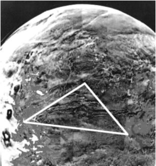
(at Lower Right)
“Capa Cornu” (Cape Horn), the lower right corner of the triangle drawn on Mars above, is located at precisely 19.5 degrees south latitude. The significance of this angle first discovered in the Cydonia complex, site of “The Face on Mars,” by Richard Hoagland et al. could now be understood as “a pointer,” directing attention to the corner angle at Capa Cornu.
The Carl Sagan-Philip Morrison team of JPL Mars specialists, working with the first Mariner photos, now appear to this researcher to have apprehended instantly, as if “illuminated” by the sight, the significance of the terrain features revealed by Mariner and using terms from Greek mythology, named corresponding Martian regions in a manner analogous to corresponding terrestrial terrain features along the Nile River and Great African Rift Valley between the Sinai and Ethiopia (which “coincidently” has a coastal region called Ophir). Greek mythology was derived from Egypt’s religion with the Egyptian names translated and “Hellenized” into Mercury, Venus, Earth, Mars, Jupiter, etc.
Popularly Known as “The Eye of Ra“
Historians have for years researched and debated the source and location of the terrain depicted on the Great Seal of the United States, whose actual origins are steeped in a mystery. Many scholars have noted the long cliffs and escarpment to be seen in the background behind the pyramid. Could the landscape depicted on the Great Seal actually be a representation of Valles Marinaris, Solis Lacus and “The Eye of Mars”?
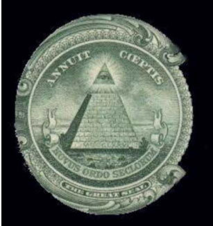
Annuit Coeptis:
“He Smiles Upon our Enterprise”
*******
Part 5:
A Study of Martian Meteorology
(Continues)
TMA-1: The Martian Artifact:
More on Martian Meteorology
The wide area of weather that I observed around Tharsis and Solis Lacus during my observation appeared to be replete with fog banks, cloud formations with vapors along its rim, similar to those, which I observed emanating from the Hellas Basin during my August 27 observation, previously cited.
The unique topography of the Tharsis highlands along the Tharsis Bulge appears to be the cause of the formation of the thousand-mile long twin rolls of altostratus clouds that I observed and noted on August 28th-29th, 2003. The cylindrical clouds that I observed may have been formed by a Martian jet stream, coursing perpendicularly across the region of the Tharsis Bulge.
As they course over the planet, fast moving Martian planetary winds seemed to cascade from the higher terrain of the Tharsis region into the long troughs formed by the two “White Tracts” (Tractus Albus Australis and Borealis), one to the south and one to the north. Thus, the heavier CO2 molecules in the atmosphere would cascade like a “windfall” (as opposed to a “waterfall” like Niagara Falls on Earth) resulting in a very rapid pressure drop “topside” across the entire length of the Tharsis region along what may be well described as “The Palisades of Tharsis.”
The cascading winds and rapid decline in atmospheric pressure above the “drop zone” would result in condensation processes nearly identical to the formation of rolling clouds, “lenticular clouds” or “Lennies”, formed as winds roll across and over mountaintops on Earth. Due to the terrain features of what I call “The Palisades of the Tharsis Bulge”, i.e., long, straight cliffs extending for over a thousand miles, the resulting cloud formations might well be described as “Tubular Lennies.”
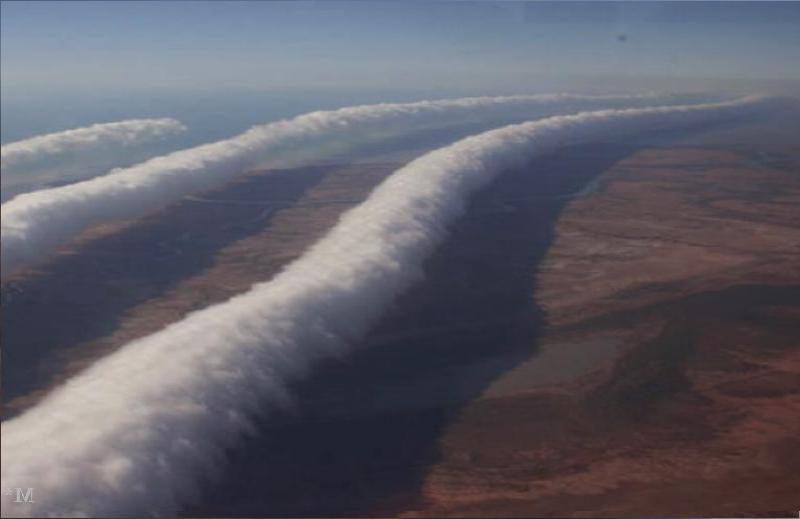
as seen by Robert morningstar on the Night of August 27-28, 2003.
Of particular interest are those to be seen forming over Mt. Rainier, WA (similar to those formed over Olympus Mons and the volcanoes of Tharsis Montes) and 3 others labeled:
The photo (above) provides a facsimile of Martian cloud characteristics seen near Solis Lacus and the Xanthe regions of Mars by the author in August 2003. If the reader can envision such clouds extending in parallel rows for over 1,000 miles, the reader will have a clear idea of Martian cloud dynamics to be seen forming along the palisades of the Tharsis Highlands and rolling off like logs from the cliffs of the Tharsis Bulge.
and the Xanthe region on a clear day.
The Mariner 9 photomap-TMA-1 comparison above shows the northern region of Solis Lacus and the Xanthe region on a clear day. In pre-2005 NASA computerized photos, large and expansive cloud formations were made to appear to be desert areas due to color level adjustment and modification of computer-generated images. I have discovered Mariner 9 photos depicting the area north and south of Valles Marinaris devoid of clouds and showing extremely accurate details of the cliffs and floor of Solis Lacus. Overlays presented here demonstrate this clearly.
These 4 panels prove geometrically that a one-to-one correspondence exists between terrain features shown in the Mariner 9 photos and details depicted in TMA-1, The Martian Artifact.details on how to set up the strobe feature and alignment of the images for comparison).
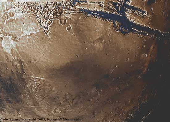
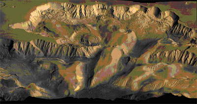
The Martian Abyss
NASA Image above, computer rectified and enhanced by RDM, shows Solis Lacus region of Mars to be well over a hundred-miles deep asteroid impact crater, which created Valles Marinaris and “The Tharsis Bulge.”
I believe that I have uncovered in TMA-1 what may truly and literally be described and deciphered as “A Message in from Mars.” TMA-1 reveals a message, inviting our attention and calling us to explore the mystery that lies inside and surrounding the remarkable region of Mars called Solis Lacus.
A Flight over The Valles Marinaris
On Mars 15th, 2006, NASA/JPL released a remarkable Mars Orbiter fly-by over Valles Marinaris and the Tharsis Montes. This amazing video will familiarize the reader with the terrain features of the region, which forms the northern border of Solis Lacus. The reader should take note of the diagrams of the region shown on the webpage below provided by the Planetary Society, which demonstrates that the cliffs of the Sinai Region, south of Candor and Mellas Chasmata, fall precipitously in an nearly vertical drop of 4.79 miles (7.7 km) before the terrains begins a downward slope into the “The Martian Abyss” of Solis Lacus stretching for several thousand miles (of which only 92.35 miles are shown using the Los Angeles basin overlay to camouflage the catastrophic event that transpired there ages ago. I advise the reader to pay particular attention to the first frame and the very last frames of the Mars Odyssey flight video, which show the northern end of Solis Lacus, giving a hint of the true dimensions of the crater. The final frame is most interesting in that it shows two large meteor or small asteroid impact craters (on the right hand side, which actually struck the cliffs but which due to the camera angle of the final frame are made to appear as if they are on flat terrain.
This writer noted these impact craters in the original Mariner photo discussed above and they have become significant landmarks in this analysis of the area.
Mars Odyssey Flight over Valles Marinaris
http://photojournal.jpl.nasa.gov/archive/PIA02891-95.mov
Mars Odyssey Still Images over Candor Chasma and Melas Chasma regions of Valles Marinaris
https://mars.nasa.gov/resources/5313/the-grand-canyon-of-mars-valles-marineris/
*******
TMA-1: The Martian Artifact
Part 6
More on Martian Meteorology
by Robert D. Morningstar
Posted: 12:48 November 15, 2006
With many thanks to
Dirk Vander Ploeg
Publisher of UFO Digest
(Copyright 2004-2006, RDM*)
A Beckoning Call
From The Beacon of a Single Bead of Hematite

A Single Bead of Hematite, embedded in “The Martian Artifact,” calls the World’s attention to a specific region of the Western terminus of the Valles Marinaris
This remarkable “artifact-within the-artifact” is clearly discernable in the Opportunity Rover image.
Of particular interest to this researcher is the mystery of what lies beneath the unique point designated by the single bead of hematite embedded in TMA-1? What does this signify and why is our attention being drawn to that region?
The first thing to find out was “What is that region called?” The most important question is “What’s there?”
shown and labeled with the corresponding features shown in an actual photo of
Mars taken by the Mars Global Explorer (inset).
Finding “The Labyrinth of Night”
When we first compared the single hematite bead’s position as seen in “TMA-1” with the Mariner 9 photo map, the precise position of the single hematite bead called our attention to a unique and remarkable complex of intertwining cliffs and canyons at the western terminus of Valles Marinaris called “Noctis Labyrinthus” or “The Labyrinth of Night.” Unlike the hundreds of thousands of randomly scattered “Marsberries” found all around the Eagle Crater site, this one, single bead of hematite appears to have been intentionally “set,” embedded like a jewel, sunken halfway, in the northwest the rim of TMA-1, designating a point, adjacent to steep slopes near the region called “Syria.”
The most important aspect of this discovery and observation is that the single bead of hematite, set upon the region of “Noctis Labyrinthus,” now provides the world with a focal point for future Mars exploration and designates a primary landing site for a manned mission to the Red Planet.
Note the fog formations emanating from the labyrinth of canyons and the collection of complete ground fog formations to be seen aggregating in the upper right quadrant.
“Eyeballing” From Altitude: A Martian POV?
TMA-1: A Point of View from Mars Orbit
I have attempted to determine the altitude of the POV (Point of View) of the designers of TMA-1 from orbit over “Sinai” and “Thaumasia,” a southern equatorial region of Mars. In roughly estimating the altitude above the planet of the POV (“Eyeballing” one might say) the author employed basic geometry with a known distance and the perspective of the object (the rate at which the planet’s curvature falls away).
To determine the altitude of the POV, I used the average scope of human vision (subtending an angle of 110-120 degrees including peripheral field) and the known diameter of Mars with the curvature of the surface “falling away” to the limb of the planet (4200 miles) as depicted in TMA-1. Using the angle of 120 degrees, I calculated the approximate altitude of the POV using the Pythagorean theorem for a 90-60-30 right triangle. With an apex angle of 120 degrees, half of which is 60 degrees, and using half the diameter of Mars as the base of the 30-60-90 degree triangle, 2100 miles, according to the FOIL formula from basic geometry, we derive:“X – The Unknown”
Solving for X, we arrive at:
60 degrees : 2100 Miles. 30 degrees : X Miles
(30* x 2100) 63,000 miles divided by 60 X = 1050 miles.
Thus, the approximate altitude of the point of view of TMA-1, above Solis Lacus, the most salient and significant topographical characteristic of the Red Planet, known as “The Eye of Mars,” would be approximately 1050 miles. This unique Martian point of view, seen from orbit over the hematite bead (designating “The Labyrinth of Night”) is near 19.5 degrees south latitude above the southern hemisphere of Mars.
The implications of this “Martian Point of View” are enormous for science, religion, mythology and Mankind.
For, from this observation, we may infer that if the manufacturers of TMA-1 had a “point of view” at all, then those who made TMA-1 were capable of space flight and must have had eyes in order to behold The Red Planet from orbit. Therefore, this artifact was made for eyes that see the world like ours see.
Could those eyes have been as human as our own?
Epilogue
*******
“Imagination is everything.
It is the preview of life’s coming attractions.”
Albert Einstein”
To Think is To Create, Imagination Becomes Reality”
T.T. Liang, Tai Chi Master
This Martian dissertation would not be complete without expressing my deep gratitude and thanks to Dirk Vander Ploeg of UFO Digest, Dr, Bruce Cornet (Phd), Kent Steadman of CyberOrbit Ezine & Richard Hoagland, Director of The Enterprise Mission (www.enterprisemission.com) whose friendship and support over the course of the last 3 decades inspired and made this investigation possible.
Author’s Note:
The views expressed above are exclusively those of the author and do not reflect the official position or opinions of NASA nor of any other government agency or scientifc group or organization.
Robert D. Morningstar
New York City
Composed between August 27-27, 2003
and May 5th, 2021
To be continued …

WOW!
LikeLike
Thanks … 🙂
“Rob Mars”
LikeLike